
Magnitude |
3.6 |
| Date & Time (UTC) | 2015-05-09 21:13:05.6 |
| Date & Time (Local) | 1394/2/20 01:43:05.6 |
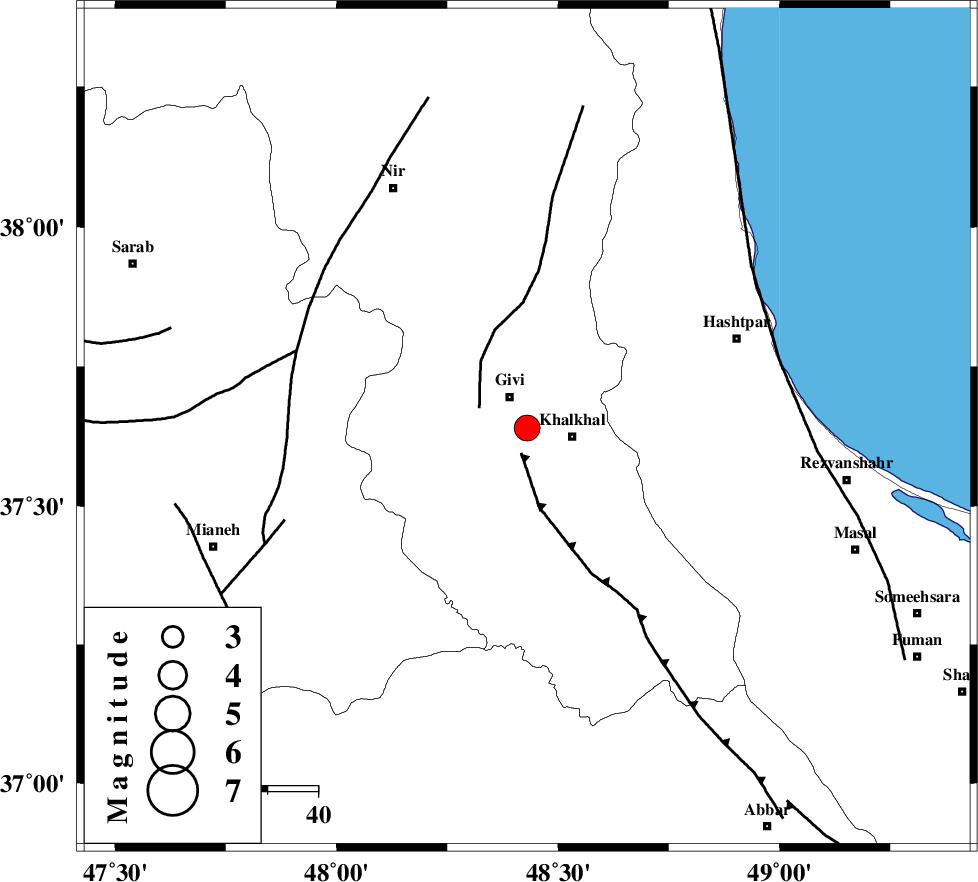
| Location | Lat:37.64 Lon: 48.43 |
| Region | Ardebil Province, 7 km Givi |
Nearest Cities |
|
| 7 km of Givi, Ardebil Province | |
| 9 km North of Gazaz, Ardebil Province | |
| 9 km North West of Khalkhal, Ardebil Province | |
| 12 km North West of Khojin, Ardebil Province | |
| 16 km East of Ganjgah, Ardebil Province | |
| Depth | 6 km |
| Agency | |
Faults within 150 km: |
|
| MASULEL_F (Length: 90 km) , Distance to epicenter: 5 km | |
| SANGAVAR_F (Length: 61 km) , Distance to epicenter: 10 km | |
| BOZQUSH (Length: 70 km) , Distance to epicenter: 48 km | |
| Number of Phases | 7 |
| RMS | 0.1 |
| Number of Stations | 7 |
| Error in Latitude | >14.9 km |
| Error in Longitude | 7.4 km |
| Error in Depth | 8.9 km |
Download waveform in seisan format
to download seisan software Click here
to access information about IIEES stations Click here
Amplitude | ||||||||
| UID | Agency | Station | Component | Amplitude | Period | Arrival Time | Proccessing Time | Signal Clip |
| 95621 | IIEES | THKV | N | 264.8 | 0.4 | 2015-05-09 21:14:34 | 2015-05-09 10:46:00 | n |
Phase | ||||||||||||
| Agency | Station | Component | Phase Type | Phase Quality | First Motion | Observed Arrival Time | Time Residual | Loc. Flag | Input Weight | Distance | Azimuth | |
| IIEES | ZNJK | Z | Pg | E | 2015-05-09 21:13:24 | -0.08 | y | 110 | 168 | |||
| IIEES | THKV | Z | Pn | E | 2015-05-09 21:13:50 | 0.01 | y | 290 | 131 | |||
| IIEES | SNGE | Z | Pn | E | 2015-05-09 21:13:51 | -0.06 | y | 299 | 199 | |||
| IIEES | CHTH | Z | Pn | E | 2015-05-09 21:13:52 | 0.01 | y | 308 | 128 | |||
| IIEES | ASAO | Z | Pn | E | 2015-05-09 21:14:00 | 0.03 | y | 372 | 157 | |||
| IIEES | DAMV | Z | Pn | E | 2015-05-09 21:14:02 | -0.12 | y | 387 | 124 | |||
| IIEES | KHMZ | Z | Pn | E | 2015-05-09 21:14:11 | 0.26 | y | 455 | 162 | |||