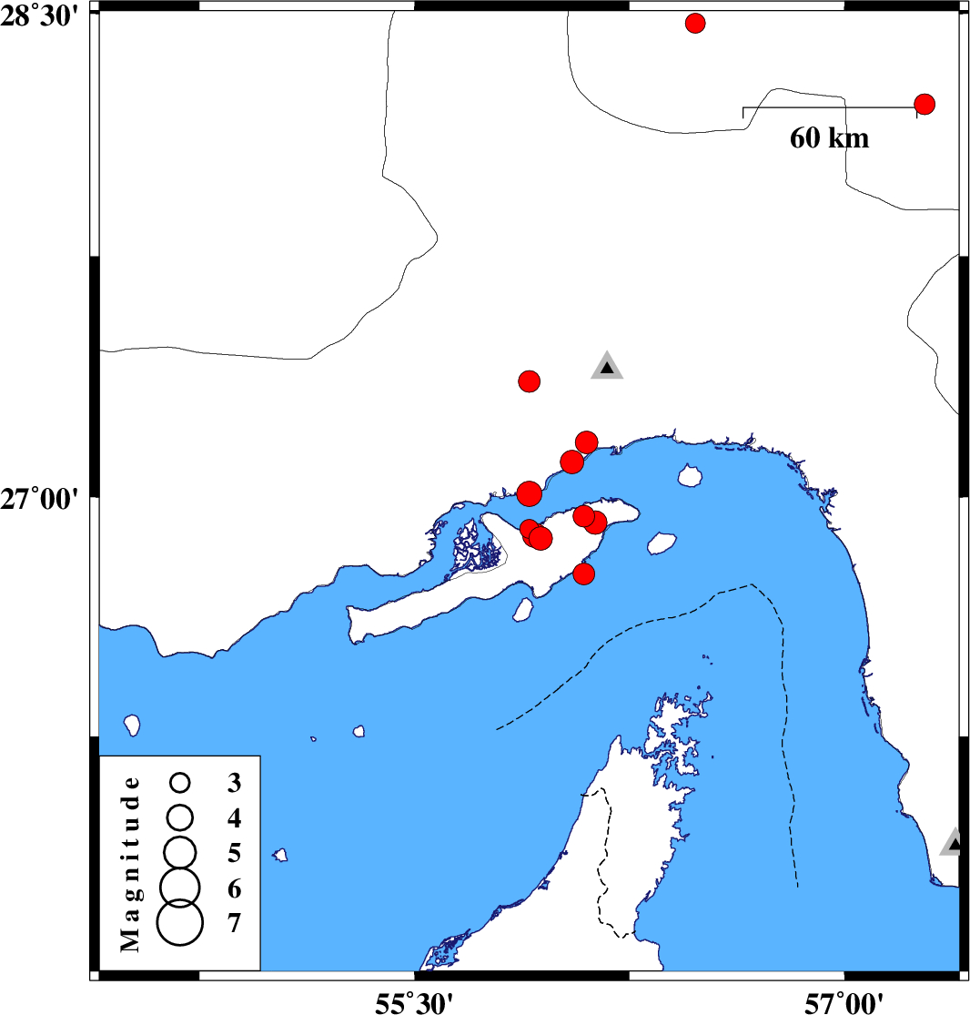
| Prel. Rep. | Date | Time(UTC) | Time(Local) | Lat. | Lon. | Depth | Mag. | Region | Waveform |
|
|
2008/10/04
|
17:35:51.7
|
21:05:51.7
| 26.87 | 55.94 | 8 |
ML:3.6
|
Persian Gulf, 33 km West of Qeshm | |
|
|
2008/10/04
|
17:29:33.1
|
20:59:33.1
| 26.94 | 56.09 | 11 |
ML:3.4
|
Persian Gulf, 17 km West of Qeshm | |
|
|
2008/10/04
|
17:12:57.1
|
20:42:57.1
| 27.01 | 55.9 | 2 |
ML:4
|
Persian Gulf, 36 km West of Qeshm | |
|
|
2008/10/03
|
21:21:32.1
|
00:51:32.1
| 27.11 | 56.05 | 9 |
ML:3.6
|
Persian Gulf, 24 km West of Bandar-e abbas | |
|
|
2008/10/03
|
18:05:36.7
|
21:35:36.7
| 27.36 | 55.9 | 2 |
ML:3.4
|
42 km North-West of Bandar-e abbas, Hormozgan Province | |
|
|
2008/10/03
|
16:28:03.1
|
19:58:03.1
| 26.76 | 56.09 | 20 |
ML:3.4
|
Persian Gulf, 27 km South-West of Qeshm | |
|
|
2008/10/02
|
00:06:18.7
|
03:36:18.7
| 27.17 | 56.1 | 18 |
ML:3.5
|
17 km West of Bandar-e abbas, Hormozgan Province | |
|
|
2008/09/30
|
17:32:45.3
|
21:02:45.3
| 28.47 | 56.48 | 14 |
ML:3.1
|
59 km North-East of Hajiabad, Hormozgan Province | |
|
|
2008/09/29
|
22:44:16.4
|
02:14:16.4
| 28.22 | 57.28 | 43 |
ML:3.3
|
50 km North-West of Kahnuj, Kerman Province | |
|
|
2008/09/29
|
04:30:20.5
|
08:00:20.5
| 26.9 | 55.9 | 7 |
ML:2.9
|
Persian Gulf, 36 km West of Qeshm | |
|
|
2008/09/29
|
03:57:48.0
|
07:27:48.0
| 26.88 | 55.92 | 6 |
ML:3.8
|
Persian Gulf, 35 km West of Qeshm | |
|
|
2008/09/28
|
12:18:44.0
|
15:48:44.0
| 26.92 | 56.13 | 15 |
ML:3.6
|
Persian Gulf, 14 km West of Qeshm | |