Home / Recent Earthquakes

| Prel. Rep. | Date | Time(UTC) | Time(Local) | Lat. | Lon. | Depth | Mag. | Region | Waveform |
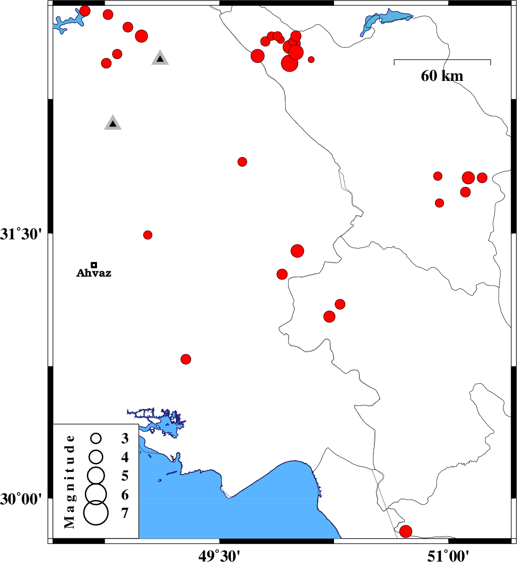
| 2014/02/03 | 11:41:37.6 | 15:11:37.6 | 31.81 | 51.22 | 14 | ML:2.9 | Chaharmahal Bakhtiari Province, 19 km South of Borujen | ||
| 2014/02/03 | 07:52:05.0 | 11:22:05.0 | 31.27 | 49.91 | 14 | ML:3.1 | Khoozestan Province, 27 km South of Bagh Malek | ||
| 2014/02/02 | 19:21:48.3 | 22:51:48.3 | 32.6 | 50 | 6 | ML:3.1 | Chaharmahal Bakhtiari Province, 19 km North-West of Chelgard | ||
| 2014/02/01 | 19:57:58.3 | 23:27:58.3 | 31.81 | 51.13 | 15 | ML:3.7 | Chaharmahal Bakhtiari Province, 23 km South-West of Borujen | ||
| 2014/02/01 | 18:43:24.4 | 22:13:24.4 | 32.6 | 49.88 | 15 | ML:2.7 | Chaharmahal Bakhtiari Province, 27 km North-West of Chelgard | ||
| 2014/02/01 | 18:03:39.1 | 21:33:39.1 | 31.73 | 51.11 | 15 | ML:2.9 | Chaharmahal Bakhtiari Province, 32 km South-West of Borujen | ||
| 2014/02/01 | 16:11:49.7 | 19:41:49.7 | 31.82 | 50.93 | 15 | ML:2.5 | Chaharmahal Bakhtiari Province, 32 km South-East of Ardel | ||
| 2014/02/01 | 00:35:05.5 | 04:05:05.5 | 32.72 | 48.77 | 14 | ML:3 | Khoozestan Province, 49 km North-West of Lali | ||
| 2014/02/01 | 00:18:39.5 | 03:48:39.5 | 32.47 | 50.1 | 14 | ML:1.9 | Chaharmahal Bakhtiari Province, 2 km Chelgard | ||
| 2014/01/31 | 14:25:15.6 | 17:55:15.6 | 32.6 | 49.84 | 18 | ML:2.5 | Chaharmahal Bakhtiari Province, 30 km North-West of Chelgard | ||
| 2014/01/31 | 11:40:47.8 | 15:10:47.8 | 32.51 | 50 | 14 | ML:4.4 | Chaharmahal Bakhtiari Province, 12 km West of Chelgard | ||
| 2014/01/30 | 22:31:38.9 | 02:01:38.9 | 32.58 | 49.9 | 35 | ML:2.2 | Chaharmahal Bakhtiari Province, 24 km North-West of Chelgard | ||
| 2014/01/30 | 18:23:08.3 | 21:53:08.3 | 32.57 | 49.98 | 6 | ML:2.6 | Chaharmahal Bakhtiari Province, 17 km West of Chelgard | ||
| 2014/01/29 | 17:22:38.9 | 20:52:38.9 | 32.65 | 48.9 | 14 | ML:3 | Khoozestan Province, 35 km North-West of Lali | ||
| 2014/01/29 | 15:48:50.5 | 19:18:50.5 | 32.54 | 49.96 | 15 | ML:3.9 | Chaharmahal Bakhtiari Province, 17 km West of Chelgard | ||
| 2014/01/29 | 08:12:20.1 | 11:42:20.1 | 32.57 | 49.8 | 18 | ML:2.8 | Chaharmahal Bakhtiari Province, 33 km North-West of Chelgard | ||
| 2014/01/29 | 04:06:00.5 | 07:36:00.5 | 32.53 | 49.97 | 14 | ML:2.8 | Chaharmahal Bakhtiari Province, 16 km West of Chelgard | ||
| 2014/01/28 | 23:52:27.8 | 03:22:27.8 | 32.56 | 50 | 14 | ML:2.7 | Chaharmahal Bakhtiari Province, 15 km West of Chelgard | ||
| 2014/01/28 | 23:47:36.5 | 03:17:36.5 | 32.45 | 49.96 | 29 | ML:4.9 | Chaharmahal Bakhtiari Province, 15 km West of Chelgard | ||
| 2014/01/26 | 22:57:33.6 | 02:27:33.6 | 31.4 | 50.01 | 16 | ML:3.8 | Khoozestan Province, 17 km South-East of Bagh Malek | ||
| 2014/01/26 | 18:09:03.7 | 21:39:03.7 | 29.81 | 50.72 | 17 | ML:3.7 | Fars Province, 33 km North-East of Bandar-e genaveh | ||
| 2014/01/24 | 16:13:55.5 | 19:43:55.5 | 31.03 | 50.22 | 18 | ML:3.4 | Kohkiluieh va boyerahmad Province, 48 km North of Behbahan | ||
| 2014/01/19 | 15:08:36.5 | 18:38:36.5 | 31.9 | 49.65 | 18 | ML:2.7 | Khoozestan Province, 22 km West of Izeh | ||
| 2014/01/18 | 12:01:27.9 | 15:31:27.9 | 32.74 | 48.62 | 18 | ML:3.1 | Khoozestan Province, 40 km North-East of Andimeshk | ||
| 2014/01/18 | 12:00:20.3 | 15:30:20.3 | 32.6 | 48.99 | 16 | ML:3.6 | Khoozestan Province, 25 km North-West of Lali | ||
| 2014/01/16 | 02:13:07.1 | 05:43:07.1 | 30.79 | 49.28 | 14 | ML:2.9 | Khoozestan Province, 28 km North of Bandar-e mahshahr | ||
| 2014/01/15 | 15:59:38.5 | 19:29:38.5 | 32.49 | 49.75 | 29 | ML:3.9 | Chaharmahal Bakhtiari Province, 35 km West of Chelgard | ||
| 2014/01/08 | 05:27:38.7 | 08:57:38.7 | 31.49 | 49.03 | 29 | ML:2.6 | Khoozestan Province, 38 km North-East of Ahvaz | ||
| 2014/01/07 | 15:29:49.7 | 18:59:49.7 | 31.1 | 50.29 | 16 | ML:3 | Kohkiluieh va boyerahmad Province, 56 km North of Behbahan | ||
| 2014/01/06 | 15:04:43.6 | 18:34:43.6 | 31.67 | 50.94 | 18 | ML:2.5 | Chaharmahal Bakhtiari Province, 22 km North-East of Lordegan | ||
| 2014/01/06 | 08:00:39.8 | 11:30:39.8 | 32.45 | 48.76 | 14 | ML:2.9 | Khoozestan Province, 33 km West of Lali | ||
| 2014/01/04 | 23:49:08.8 | 03:19:08.8 | 32.5 | 48.83 | 17 | ML:2.8 | Khoozestan Province, 28 km North-West of Lali |