Home / Recent Earthquakes

| Prel. Rep. | Date | Time(UTC) | Time(Local) | Lat. | Lon. | Depth | Mag. | Region | Waveform |
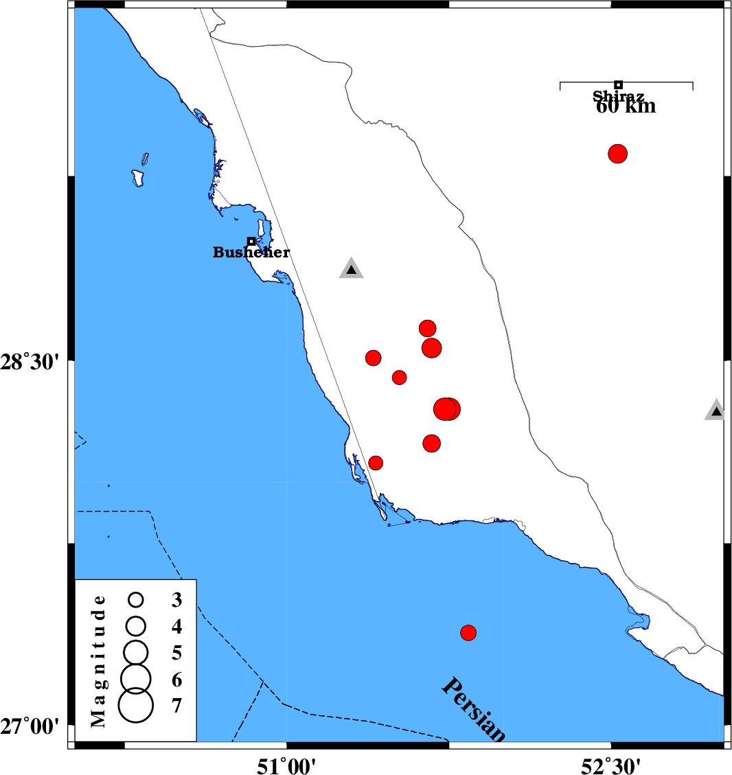
| 2013/09/05 | 22:09:08.4 | 02:39:08.4 | 28.43 | 51.52 | 38 | ML:2.9 | Bushehr Province, 29 km South-East of Khormog | ||
| 2013/09/01 | 15:58:58.4 | 20:28:58.4 | 29.34 | 52.53 | 15 | ML:4 | Fars Province, 31 km South of Shiraz | ||
| 2013/08/24 | 22:41:27.9 | 03:11:27.9 | 28.55 | 51.67 | 14 | ML:4.1 | Bushehr Province, 32 km South-East of Khormog | ||
| 2013/08/24 | 22:39:13.0 | 03:09:13.0 | 28.16 | 51.67 | 18 | ML:3.7 | Bushehr Province, 53 km North-West of Bandar-e kangan | ||
| 2013/08/17 | 03:40:03.2 | 08:10:03.2 | 27.38 | 51.84 | 40 | ML:3.3 | Persian Gulf, 55 km South-West of Bandar-e kangan | ||
| 2013/08/16 | 14:03:31.7 | 18:33:31.7 | 28.51 | 51.4 | 36 | ML:3.2 | Bushehr Province, 16 km South of Khormog | ||
| 2013/08/15 | 08:03:27.4 | 12:33:27.4 | 28.08 | 51.41 | 28 | ML:3 | Bushehr Province, 64 km South of Khormog | ||
| 2013/08/14 | 04:06:24.0 | 08:36:24.0 | 28.63 | 51.65 | 16 | ML:3.5 | Bushehr Province, 27 km East of Khormog | ||
| 2013/08/10 | 17:20:46.1 | 21:50:46.1 | 28.3 | 51.73 | 15 | ML:4.6 | Bushehr Province, 53 km South-East of Khormog | ||
| 2013/08/10 | 17:05:33.7 | 21:35:33.7 | 28.3 | 51.75 | 15 | ML:4.7 | Bushehr Province, 54 km South-East of Khormog |