Home / Recent Earthquakes

| Prel. Rep. | Date | Time(UTC) | Time(Local) | Lat. | Lon. | Depth | Mag. | Region | Waveform |
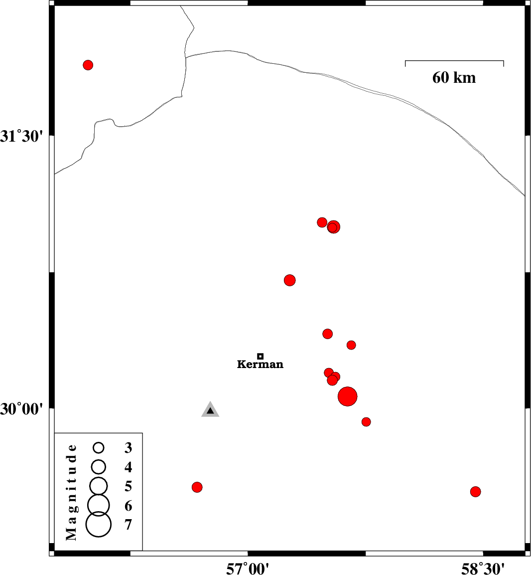
| 2017/08/12 | 10:29:35.1 | 14:59:35.1 | 30.707 | 57.266 | 14 | ML:3.2 | Kerman Province, 50 km North-East of Kerman | ||
| 2017/08/08 | 03:52:31.8 | 08:22:31.8 | 30.35 | 57.658 | 14 | ML:2.5 | Kerman Province, 56 km -East of Kerman | ||
| 2017/08/08 | 01:30:18.7 | 06:00:18.7 | 31.883 | 55.981 | 14 | ML:2.8 | Yazd Province, 63 km North-East of Bafq | ||
| 2017/07/30 | 07:49:33.9 | 12:19:33.9 | 30.155 | 57.537 | 14 | ML:2.9 | Kerman Province, 46 km South-East of Kerman | ||
| 2017/07/26 | 06:09:19.0 | 10:39:19.0 | 30.411 | 57.507 | 14 | ML:2.8 | Kerman Province, 43 km North-East of Kerman | ||
| 2017/07/25 | 20:40:18.6 | 01:10:18.6 | 29.561 | 56.676 | 15 | ML:3 | Kerman Province, 37 km North of Baft | ||
| 2017/07/23 | 23:38:04.6 | 04:08:04.6 | 30.175 | 57.557 | 14 | ML:2.7 | Kerman Province, 48 km South-East of Kerman | ||
| 2017/07/23 | 20:22:42.0 | 00:52:42.0 | 30.196 | 57.515 | 14 | ML:2.7 | Kerman Province, 43 km -East of Kerman | ||
| 2017/07/23 | 17:32:12.3 | 22:02:12.3 | 30.065 | 57.634 | 11 | Mb:5.5 | Kerman Province, 59 km South-East of Kerman | ||
| 2017/07/21 | 01:27:53.7 | 05:57:53.7 | 29.537 | 58.45 | 15 | ML:3 | Kerman Province, 48 km North of Bam | ||
| 2017/07/20 | 15:20:38.1 | 19:50:38.1 | 30.996 | 57.538 | 14 | ML:2.5 | Kerman Province, 75 km South-East of Ravar | ||
| 2017/07/20 | 07:03:50.1 | 11:33:50.1 | 31.024 | 57.473 | 14 | ML:2.8 | Kerman Province, 68 km South-East of Ravar | ||
| 2017/07/15 | 04:41:07.2 | 09:11:07.2 | 31 | 57.545 | 15 | ML:3.7 | Kerman Province, 76 km South-East of Ravar | ||
| 2017/07/13 | 23:29:36.5 | 03:59:36.5 | 29.925 | 57.753 | 18 | ML:2.6 | Kerman Province, 76 km South-East of Kerman |