
| Prel. Rep. | Date | Time(UTC) | Time(Local) | Lat. | Lon. | Depth | Mag. | Region | Waveform |
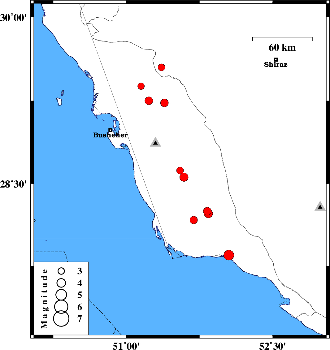
| 2014/01/06 | 23:18:23.1 | 02:48:23.1 | 28.62 | 51.55 | 14 | ML:3.2 | Bushehr Province, 18 km East of Khormog | ||
| 2014/01/03 | 14:21:58.1 | 17:51:58.1 | 27.85 | 52.05 | 17 | ML:4.7 | Bushehr Province, 2 km Bandar-e kangan | ||
| 2013/12/19 | 18:55:09.6 | 22:25:09.6 | 29.23 | 51.39 | 8 | ML:3.7 | Bushehr Province, 18 km East of Borazjan | ||
| 2013/12/18 | 19:45:31.9 | 23:15:31.9 | 28.56 | 51.59 | 7 | ML:4 | Bushehr Province, 23 km East of Khormog | ||
| 2013/12/18 | 10:59:56.3 | 14:29:56.3 | 29.25 | 51.23 | 6 | ML:3.6 | Bushehr Province, 2 km Borazjan | ||
| 2013/12/16 | 01:42:19.5 | 05:12:19.5 | 28.17 | 51.69 | 14 | ML:3.5 | Bushehr Province, 53 km North-West of Bandar-e kangan | ||
| 2013/12/15 | 21:36:31.2 | 01:06:31.2 | 28.25 | 51.83 | 14 | ML:3.6 | Bushehr Province, 52 km North-West of Bandar-e kangan | ||
| 2013/12/10 | 16:12:01.6 | 19:42:01.6 | 29.55 | 51.36 | 17 | ML:3.3 | Fars Province, 30 km West of Kazerun | ||
| 2013/12/10 | 06:59:27.6 | 10:29:27.6 | 28.23 | 51.84 | 8 | ML:3.9 | Bushehr Province, 50 km North-West of Bandar-e kangan | ||
| 2013/12/08 | 02:56:00.1 | 06:26:00.1 | 29.38 | 51.15 | 4 | ML:3.1 | Bushehr Province, 14 km North of Borazjan |

 IIEES All Rights Reserved