Home / Recent Earthquakes

| Prel. Rep. | Date | Time(UTC) | Time(Local) | Lat. | Lon. | Depth | Mag. | Region | Waveform |
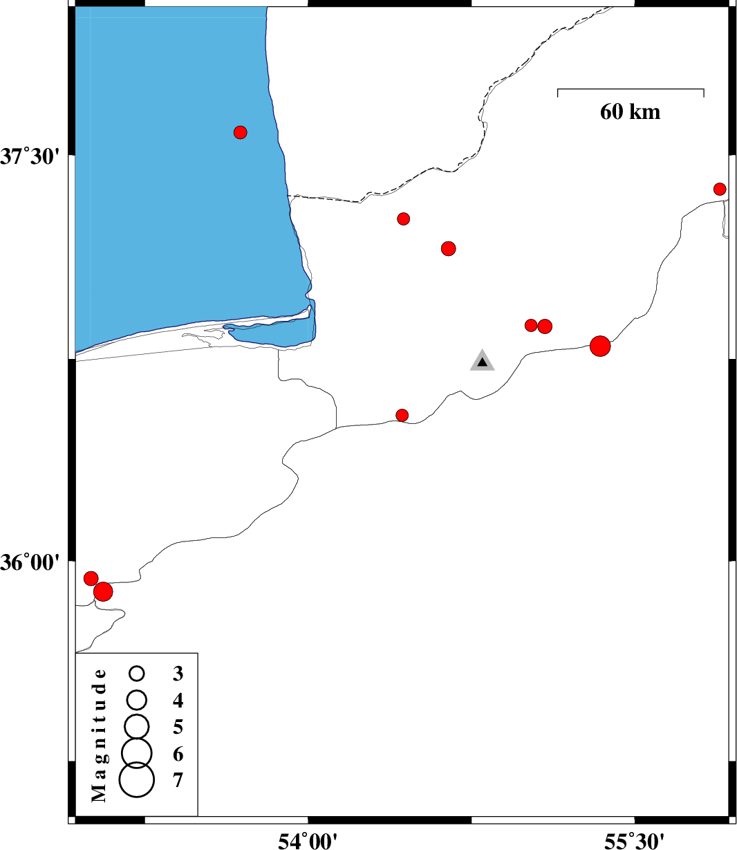
| 2018/02/23 | 07:33:05.1 | 11:03:05.1 | 36.541 | 54.431 | 14 | ML:2.5 | Golestan Province, 33 km South of Gorgan | ||
| 2018/02/21 | 10:14:28.7 | 13:44:28.7 | 37.156 | 54.644 | 16 | ML:3 | Golestan Province, 23 km North-East of Aq Qaleh | ||
| 2018/02/17 | 22:32:12.6 | 02:02:12.6 | 36.797 | 55.341 | 15 | ML:4.2 | Semnan Province, 30 km South-East of Ramian | ||
| 2018/02/17 | 12:02:29.2 | 15:32:29.2 | 36.87 | 55.087 | 16 | ML:2.9 | Golestan Province, 17 km South of Ramian | ||
| 2018/02/17 | 08:17:38.1 | 11:47:38.1 | 36.874 | 55.024 | 16 | ML:2.6 | Golestan Province, 14 km -East of Ali Abad | ||
| 2018/02/14 | 19:57:58.4 | 23:27:58.4 | 37.374 | 55.89 | 15 | ML:2.5 | Golestan Province, 35 km -East of Kalaleh | ||
| 2018/02/11 | 12:28:20.7 | 15:58:20.7 | 37.266 | 54.438 | 14 | ML:2.5 | Golestan Province, 28 km North of Aq Qaleh | ||
| 2018/02/07 | 13:23:23.1 | 16:53:23.1 | 35.934 | 53.002 | 15 | ML:2.9 | Mazandaran Province, 21 km South of Pol-E-Sefid | ||
| 2018/01/30 | 23:59:12.0 | 03:29:12.0 | 37.582 | 53.689 | 15 | ML:2.7 | Caspian Sea | ||
| 2018/01/27 | 12:39:59.9 | 16:09:59.9 | 35.885 | 53.058 | 17 | ML:4 | Semnan Province, 25 km South of Pol-E-Sefid |